-
Hi everyone,
As you all know, Coffee (Dean) passed away a couple of years ago. I am Dean's ex-wife's husband and happen to have spent my career in tech. Over the years, I occasionally helped Dean with various tech issues.
When he passed, I worked with his kids to gather the necessary credentials to keep this site running. Since then (and for however long they worked with Coffee), Woodschick and Dirtdame have been maintaining the site and covering the costs. Without their hard work and financial support, CafeHusky would have been lost.
Over the past couple of weeks, I’ve been working to migrate the site to a free cloud compute instance so that Woodschick and Dirtdame no longer have to fund it. At the same time, I’ve updated the site to a current version of XenForo (the discussion software it runs on). The previous version was outdated and no longer supported.
Unfortunately, the new software version doesn’t support importing the old site’s styles, so for now, you’ll see the XenForo default style. This may change over time.
Coffee didn’t document the work he did on the site, so I’ve been digging through the old setup to understand how everything was running. There may still be things I’ve missed. One known issue is that email functionality is not yet working on the new site, but I hope to resolve this over time.
Thanks for your patience and support!
You should upgrade or use an alternative browser.
Best GPS value/quality/price/features. Which one do you use and why?
- Thread starter Alberto
- Start date
Alberto
Husqvarna
AA Class
MotionX GPS app if you have a smartphone - does everything my handheld GPS does and a lot cheaper.
Good info, can't seem to find it on the Play Store, as I have android :-(
Cosmokenney
Husqvarna
Pro Class
Good info, can't seem to find it on the Play Store, as I have android :-(
Since you have an android, try Maps.Me. Completely off-line. Relatively accurate.

What about GPS files, how do I get and import some routes/trails?
With the garmin and a few programs it is amazingly EZ to both transfer and to draw and plan and then upload.
Cosmokenney
Husqvarna
Pro Class
What about GPS files, how do I get and import some routes/trails?
Best way is to email them to your self. When you tap the attachment in the email, Maps.Me takes over and saves the KML/KMZ file on the device and they become available from within the app. Another android app that I really like is Maplets. Here in the states it has an amazing database of downloadable georeferenced map files for places like OHV areas, State and local parks and so on. They usually have the official trails on them and all of the rules and regs.
Johnrg
Husqvarna
Pro Class
There are secondary applications too so you can use existing trail guide images superimposed on your topo maps. G-Raster is one and it slices up images into small easily digestible files within a KMZ (google earth file) so you can bring it into Basecamp and the GPS. (You first take a map image and open Google Earth, then select "add" then "image overlay". You reposition the image so it matches points in the Google map and save as a KMZ file. Open KMZ in G-Raster and it spits out the sliced and diced new KMZ.)
The 62s is a nice size too as I take it with me when mountain biking as well. You can set it up with the included profiles for road use, hiking/trail, mtb/trail, Husky/trail so your interface can be road and route based with directional arrows for roads or follow tracks/trails. Pretty deep, and I learn more as I use it.
When seeking base maps it comes with a global map but if you own a Garmin road type gps you can pass those street maps to the gps too using Basecamp. Depending where you live you do need a topo base map but this website has been great for topo maps of other states... http://www.gpsfiledepot.com/maps/state/all . Thes take up some space on your computer but free is a great price and got me across the US recently just fine. Also... When you need to create a ride and scout out what others have already ridden and mapped but are not generally known of go here... http://www.gpsxchange.com/phpBB2/index.php .
Post one track you have made yourself and you are then entitled to download all the tracks you want.
Wire Kit:
http://www.amazon.com/Garmin-010-11131-10-USB-Power-Cable/dp/B004M4TZF6/ref=sr_1_11?ie=UTF8&qid=1408570982&sr=8-11&keywords=garmin gps wire
G-Raster:
http://gpsinformation.org/G-Raster/G-Raster.html

glangston
Husqvarna
Pro Class
Would like the larger screen Garmin down the road but not a big deal. 60 has been improved quite a bit but the case remains similar.
w2ge
Husqvarna
B Class
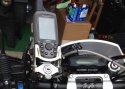
I have it mounted in a locking Touratech shock mount along with a safety backup wired tether.
Nothing like a GPS, greatest invention since the spork, or Foon.
")
Attachments
shilo020
Husqvarna
AA Class
reveille
Husqvarna
Pro Class
Johnrg
Husqvarna
Pro Class
http://www.amazon.com/Mount-RAP-274...=1408582554&sr=8-2&keywords=ram+bicycle+mount
http://www.amazon.com/Ram-Mount-Cra...=1408582650&sr=8-3&keywords=ram+mount+for+62s
River-Runner
Husqvarna
AA Class
Garmin 60csx. Small screen but adequate. Use my phone a bit too. I don't hardwire mine but do have the ability to run it off the battery if needed.
Would like the larger screen Garmin down the road but not a big deal. 60 has been improved quite a bit but the case remains similar.
We use the Garmin 60csx's as well. The Gold Standard for many years. They communicate well with your PC which makes planning trips easier - not all of the Garmin's play well with your PC. They are getting cheap used as well. I bought a 62 series, but went back to using the 60's series. The RAM Mounts are a great product. Very little problem with the RAM Mount shaking loose or moving while riding.
I've found trying to use my Samsung Galaxy S-4 phone with Backcountry Navigator is tough as the screen get's washed out by the sun. I was really pumped up about using Backcountry Navigator on my Samsung Galaxy Note 10.1 Tablet with bigger screen, which works really well at home - but it too had the problem of the screen getting washed out by the sun or just bright light - was not worth trying to use outdoors.
Tinken
Husqvarna
Pro Class
However, if money is no object and you have to have the absolute best, the Garmin Zumo 590LM is the hot ticket. And yes, you can load topographical maps right onto the 590lm.
zūmo 590LM depicts 3-D terrain so you know what to expect as you ride through the landscape. With TracBack®, you can navigate right back to where you started, along the same route.
https://buy.garmin.com/en-US/US/on-the-road/motorcycles/zumo-590lm/prod145273.html
wrtimmy
Husqvarna
AA Class
Go out with a charged battery, open up the app, set it to record your track and turn off the screen - in the backpack it goes.
I set my into airplane mode once it's running but really there's no need - I commute 50 minutes home from work and it running my whole drive home and barely made a difference to my battery life (HTC one).
I'd recommend it for sure.
https://play.google.com/store/apps/details?id=com.crittermap.backcountrynavigator.license